week 1 - DP2

Updated: May 18
DESN801 // 28/04/26
Proof-of-Concept Project Brief
Project Name: TBC
Project Description:
This proof-of-concept studio project will involve the creation of a technology-driven installation employing tangible interaction designed to transform a residual urban site, chosen through carrying out site research and analysis, with the goal of encouraging engagement with an aspect of that space such as its history, environment, materials or physical structure.
Research Question:
How can tangible interactive technologies transform residual urban space to support lingering as a form of engagement with such space?
I aim to address this question through the selection, research and analysis of a residual urban site, and the development an installation for this site, ultimately evaluating whether such an installation supports increased engagement with a space and what the nature of this engagement is.
Project Scope:
The project’s scope will include two phases:
Site research and analysis, to choose a final site for the installation to be designed around,
The design and development of a representative installation, as full-scale as the design allows while remaining feasible in the given timeframe (see timeline below), including a visual representation of the intended design situated in the chosen site.
This scope allows for crucial emphasis on the site analysis and selection aspect of my research which will contribute to the ideation and development of an appropriate installation designed with this site in mind. Through this emphasis, I also hope to gain necessary skills in conducting research and analysis of a site using a variety of digital and analogue methods (see methodology below).
Methodology:
The site research and analysis phase of the project will involve researching multiple residual urban spaces in/around Auckland CBD using sources such as GeoMaps (with contour maps and aerial photography), Heritage NZ for heritage information and archaeological records, and Digital NZ for historic photographs and artefacts. Once sites of interest are identified, site visits to each of these sites will be conducted to take photos and initial observations of each one before then quantitatively and qualitatively comparing all the sites to each other to choose a final site for design.
Once the final site is chosen, more in-depth observations will be undertaken at the chosen site such as photogrammetry, sound recordings, and note-taking in at least two different conditions (varying weather and time of day) where feasible. From there, ideation of potential installations will be carried out via sketching and brainstorming to address the residuality of the site and transform it for more effective public engagement, incorporating the research conducted around the site. This method will also involve sketching directly on photos of the site to communicate how the design is embedded in the space.
After choosing an installation concept, rapid prototyping with relevant technology (see reources below) will be carried out to develop a full-scale installation, or partial installation, as a representation of the intended design to be situated in the site. A partial installation may be developed if the full scope of the work is not feasible to create at full-scale in the given timeframe. This development will also take into consideration the use of existing structures on the chosen site and employing means to depict representations of these where appropriate to physically demonstrate the full-scale installation. For example, if the installation is designed to be erected on a building wall at the site, the physical work will be demonstrated on a representative wall where feasible.
Finally, in addition to the physical installation prototype, a final visual representation will be provided to demonstrate how the full installation would be situated in the chosen site. This may include a scale model or visuals created in Photoshop depending on the time available, the chosen site, and the design being implemented.
Objectives and Evaluation Criteria:
To evaluate the successes and failures of the project, particularly the interactive installation developed for the chosen site, user testing will be carried out by bringing peers from our studio space to the chosen site (or showing photos of it if a site visit isn’t feasible) and then having them interact with the installation so that they can compare and contrast the experience of moving through the space with and without the installation there. Through conversational interviews, I will collect data on each user’s experience as well as my own and summarise these results to evaluate the successes and drawbacks of my work.
Important criteria for evaluating my work [the installation] are as follows:
Does the work meaningfully transform the chosen space?
Does the impact of the installation have a net positive on users of the space?
Does the work disrupt any current/prior use of the space in a negative way?
Does the work invite engagement from passersby?
Does the work encourage lingering (in a way that is appropriate for the chosen site)?
Is the nature of this lingering meaningful for the chosen site (eg. engaging with the space, its history, etc.)?
These criteria may be evaluated by asking users these questions and receiving responses via a 5-point Likert-type scale.
Resources:
For site analysis, expected resources required include:
Camera [self-supplied]
Sound recorder [borrowed from Loan Central]
Insights from experts in site analysis (urban planning, etc.) able to advise on conducting such analysis while being mindful of ethics
For developing the interactive installation, expected resources required include:
Projector [borrowed from Loan Central]
Sound systems? (depends on design)
Lighting systems? (depends on design)
Computer, for software such as TouchDesigner, Photoshop and CAD [self-supplied]
Hardware — microcontrollers, sensors, wires, etc. [self-supplied and from workshops]
Relevant physical materials [to be sourced]
Wood, metal, textiles, organic materials (plants etc.), relevant to chosen site
Expertise from lab technicians where required for technology/machine use
Timeline:
The following timeline will be followed to carry out this project:
Phase 1 — Weeks 1-2 (April 21st - May 4th): site analysis and research, choosing site, installation ideation through sketching and brainstorming
Phase 2 — Weeks 3-4 (May 5th - May 18th): continuation of ideation and refining concepts, rapid prototyping and testing of installation ideas
Final Week — Week 5 (May 19th - May 25th): finalising installation concept including physical prototypes, visual representations depicting installation in chosen site, and documentation of work for presenting
Analyse and Report:
To document the project’s development, a digital notebook will be kept (eg. on Notion) to keep track of rough notes, research and ideas. Online blogs will be used to provide weekly updates, collating the progress and learnings made so far. Presentation of work to studio peers will be achieved through the physical installation, a slidedeck summarising my research and site analysis insights as well as my prototyping process, and visual representations of the installation situated in the chosen site. Finally, the physical installation and feedback from peers will be documented through a mix of photos, videos and written insights to be shared in a final blog post.
Week 1 Progress
Case Study: St. Paul's Arcade Tactical Urbanism (presented in class)
To begin Phase 1 of this Proof-of-Concept project, I started by taking notes of the St. Paul's Arcade Tactical Urbanism case study presented in class (Gallagher, 2026) to help inform my site analysis and ideation process. Up to this point, I had not undertaken much site analysis beyond simple observations and photography, so I wanted to get a sense of what methods were typically used for similar projects to help inform which methods I might try. I made the following notes of the aforementioned case study:
Site analysis:
Involved background research, such as the original name of St. Paul's street, noting the location and its geographical context of being situated at the confluence of the Rangipuke Ridge and Waihorotiu Valley.
Observations on-site involved noting key crossing locations and key activities on the street, such as pedestrians walking, brief meet-and-chat moments ("water-cooler moments"), little lingering, and negotiating moments between road and footpaths through criss-crossing or slowing down. This also involved noting which aspects they wanted to emphasise or encourage through the installation, such as the conversational moments.
Architectural observations on-site involved noting the "grey gridlines" of the site that didn't reveal the rich historic, geographic and cultural narratives of the place.
Other observations also included feasibility considerations such as noting specific areas that would be within or outside of the scope of the project and keeping a minimum width for traffic.
Methods also involved taking photos of the site to sketch/annotate, and the creation of a 1:100 site model.
Ideation:
From background research, the group identified themes they wanted to include, such as that of flowing contours, waterways and bodies moving. This led to the idea of a "wandering line":
The line would implement the theme of flowing water and soften rigid geometries of the street,
This line would also contrast concrete bench elements implemented on site, which are stable, slower and more static,
This theme also re-enacts the slow pooling motion that once existed through motion of waterways in the area, thus implementing a historical and environmental narrative.
Another goal from site analysis was holding people in the space for longer, building on the conversational meeting moments previously observed.
Methods for ideation involved mindmapping in Miro, sketching key concepts and creating models (especially doing these from different angles of the site), annotating photos of concrete surfaces, creating concrete cast forms, conceptualising "threshold modules", and creating layered drawings.
From these notes, I identified key methods that were new to me and that I would aim to test throughout this project:
Site analysis methods: conducting background research including environmental and historical considerations, conducting observations on-site through noting people's movements such as where they might negotiate with parts of the urban landscape (walkways, obstacles, seating places, etc.) and with other people, taking photos of the site from different angles, and creating a scale model.
Ideation methods: mindmapping, annotating photos, sketching concepts from different angles, identifying key themes for the installation based on site research and analysis, and choosing goals for the site that the installation would aim to address.
Site Research: The Strand Station
Having analysed this case study, I was able to go into this project with a much clearer idea of the potential methods and processes I could undergo to conduct site analysis and research and use this to fuel my installation development. This week, I decided to focus solely on researching possible residual urban spaces to pick a variety of sites of interest before narrowing down to one site for further analysis and installation development.
Limiting myself to the Auckland CBD region to narrow my scope, I looked at aerial photography from Auckland Council's GeoMaps (Auckland Council, n.d.), scanning for changes in infrastructure that could indicate the creation of residual spaces. One such space I found was a closed-off space behind The Strand Station in Parnell (Figure 1), a space I have passed a few times while on trains between Newmarket and Waitematā.

Looking at aerial photography and doing some more research into the history of The Strand Station, this residual space used to be made entirely up of the Auckland Railway Station and connecting tracks until the early 2000s when railway tracks were re-routed to Waitematā, closing off the outlined space from the public. The Auckland Railway Station was the main station servicing the CBD region from its opening in 1930 (the previous station being located at Queen Street since 1885) until its closure in 2003 when Waitematā Station was opened (Heritage New Zealand Pouhere Taonga, n.d.-a; Wikipedia contributors, n.d.). From this year until 2011, the station was almost completely disused (with the exception of one platform that remained for limited use), and the nearby Railway Station building (to the left of the outlined space) converted to university accomodation before eventually becoming the Grand Central apartments.
In 2011, two of the station's old platforms (including the platform that was still in use during the 2000s) were redeveloped for anticipated use during the Rugby World Cup, although they were never used for this purpose in the end (Wikipedia contributors, n.d.). Instead, the platforms eventually became the final stop for inter-city trains running to/from Hamilton and Wellington via Te Huia and the Northern Explorer, respectively. Other platforms were also redeveloped for stabling of Auckland Transport trains. During this renovation period, some of the old platform canopies were demolished but others kept to preserve the site's heritage status.
Some more observations can be made from aerial photography of the region (see Figure 2):
The trees behind the platforms appear to have been planted in the 1940s-50s, with some of them taken down in the 2000s when railway was re-routed to Waitematā (see red ovals),
The disused area behind the train station is currently paved over, although aerial photography from the 1940s shows that railway used to exist there. The 1970s aerial photography shows this section being turned into a road, possibly to serve as pickup/drop-off zones, with a small parking lot and turnaround loop at the end (see orange oval).
The Strand Over-Rail Bridge, as well as The Strand road itself, have remained the same since the 1940s, although it appears Quay Street was moved further south between the 1990s and the early 2000s (see green oval).
Many of the current surrounding buildings, such as Spark Arena, eating establishments off of Quay Street, and some residences and other buildings were constructed fairly recently in the early 2000s (see yellow ovals).
Some of the old 1930 concrete canopies continued to be demolished after the railway station was redeveloped after the electrification of Auckland's rail line in 2014 (see pink oval).
Reclamation of the nearby harbour for port expansion occurred between the 1950s-60s, with other sections continuing to undergo reclamation beyond this timeframe (see purple oval).
As stated before, the railway was re-routed to Waitematā in 2003, causing the loss of public accessibility of this residual space (see blue oval).

To conduct further research on the site, I analysed newspaper articles from pivotal moments in the station's history, such as its opening in 1930 and its redevelopment in the early 2010s. From these, I learned that the new station in 1930 was very welcome as it would provide a station that would instil "civic pride" and be worthy of the Auckland city (in the eyes of its residents) and not be a source of embarrassment to show off to newcomers, as the old station on Queen Street was perceived to be ("Auckland station," 1930; Davidson, 1927; Davidson, 1931a; Davidson, 1931b; "New Railway Station," 1930; O.A.G., 1930; O’Hara, 1927; "Railways problem," 1930). These papers also revealed that many of the materials used to construct the nearby Railway Station building were sourced from New Zealand, such as "Whangarei marble" and "Coromandel granite", and that a tramway track had been placed to connect the station with the rest of the city (O.A.G., 1930).
More recent articles from 2011 reveal that the old canopies that were kept in the now-residual space behind the redeveloped platforms had been under threat of demolition ("Demolition threat to old station canopies," 2011). Ultimately, Mike Lee, an Auckland Transport board member, fought for the canopies to be kept due to their heritage status which led to the "retention of representative section of canopies in the non-operational platform area" (Auckland Transport, 2011). Another article from the same year reveals that the tramlines connecting this station to the rest of the CBD area were pulled up in the 1950s, leaving the station isolated and possibly contributing to declining use over the next few decades (Dearnaley, 2011). This same article also mentions that signs were placed around one of the canopy sections (the only remaining one on the side of the platforms that were still in use) to share heritage information about the site to passersby and passengers.
I also looked at historic photographs from the 1920s to its final days of use before its closure in 2003 (Figure 3). These photos demonstrate the different kinds of trains that used this station, as well as some cars parked around the area, and even some people using the station, pictured on the platforms underneath the canopies. Such photos are in stark contrast to photos taken in the 2000s after the station was closed (Figure 4), showing weeds and grass overtaking the old railway tracks, until the station's redevelopment in 2011.


Other photos can be found at a blog published in 2009, but their author and date are unknown (Timespanner, 2009).
Finally, I dug into Māori history of the site as discussed in a 2025 archaeological assessment of nearby areas in Parnell (Farley & Low, 2025). This report detailed the geographical features of the area before land reclamation was carried out in the 1800s, stating that the area was composed of a "series of bays with high headlands enclosing low-lying land". The report also details that activities in the area before European settlers were "more ephemeral, such as landing waka and harvesting shellfish and fishing" rather than activities that would leave a noticeable trace on the land. The area is known to Māori as Te Tōangaroa (named Mechanics Bay by European settlers), a name that means "the long dragging of waka" and referred to the long path and large effort required to drag waka to the shore during low tide due to the bay's shallow nature. The archaeological report also details two streams that ran in the bay, the western one being Waiparuru and the eastern Waipapa, which was also the location of a fishing village by the same name. After the signing of the Treaty of Waitangi, Apihai Te Kawau, the chief of Ngāti Whātua Ōrākei, gave land to the Crown (an act known as tuku whenua), contributing to "a vision of shared prosperity" for both Māori and Pākehā (Te Tōangaroa, n.d.).
This report also details an era of trade between Māori and Pākehā in this area, where a hostelry was constructed for Māori to stay overnight while in the area trading fresh food. Before the land reclamation, the location of the shoreline along The Strand allowed for Māori to land canoes directly opposite this hostelry. The report also shows that the land that the site of interest behind The Strand Station is located on was reclaimed in 1915 (the original shoreline followed The Strand road, so this land was originally underwater).
After conducting this research, I also reached out to KiwiRail to inquire about accessing the site of interest behind the railway station. Through this conversation with one of their Community Engagement Advisors (my utmost gratitude goes out to Sasha!), they shared that a section of the site of interest is owned by Whai Rawa, the investment company of the Ngāti Whātua Ōrākei group (Ngāti Whātua Ōrākei Whai Rawa, n.d.). Further research showed that Ngāti Whātua Ōrākei also had proposed plans for the area to create north-south pedestrian connections throguh a de-industrialised port, building on the site's history as landing sites for waka (Warren and Mahoney, n.d.). This plan would see the residual site of interest behind the train station turned into a publicly-accessible park, showing further interest in redeveloping this currently unused land for public benefit.
I ended up visiting the area surrounding the site this week to see where the original platforms could best be viewed from publicly-accessible areas (Figure 5). I found the experience quite frustrating as most areas close to the station were not accessible: the parking lot to the west of the station, behind Spark Arena, was a staff-only area, and the area behind the Grand Central apartments was fenced off as well. The residual space was somewhat visible from behind the food establishments off of Quay Street, but the ground slopes downwards towards this street so the platforms were too high up to be properly seen. At The Strand Station itself, fencing and trains in the stabling yard prevent the old platforms from being seen as well. I also found it quite exhausting walking around the station, as the only way to get to The Strand Station from Quay Street was to walk all the way around to Spark Arena or to the Railway Over-Bridge. The best way to see the residual space was from the inside of a passing train heading to Newmarket, but even this is difficult with fencing in the way.
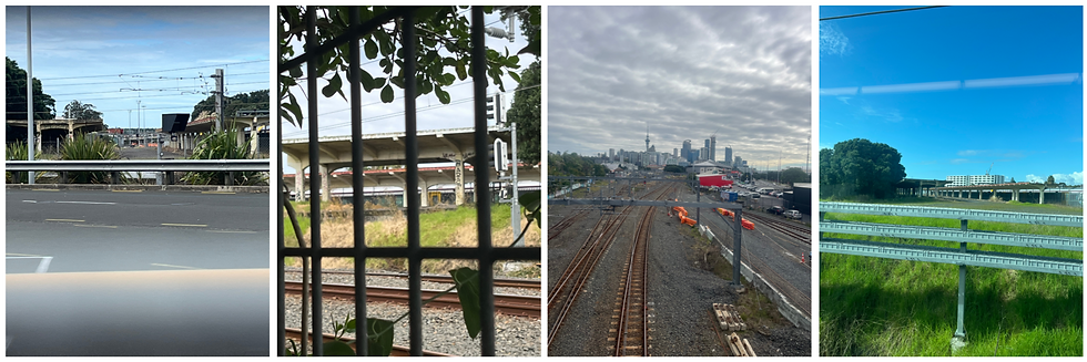
More photos of my visit this week can be seen here: https://www.dropbox.com/scl/fo/taub0mfstx0e2b2fw5nxi/AMEmweqMyifASO1xJeLiijQ?rlkey=2vpfp37df76o5pq0eonkiw06r&st=9kf8b11w&dl=0
For more of the research and notes I took of the site, see my Notion page: https://www.notion.so/Site-Research-The-Strand-Station-34a225c6436580238a7cf0b2c7615451?source=copy_link
Site Research: Symonds Street Cemetery
Another site of interest that I discovered during this week was the Symonds Street Cemetery. Aerial photography showed that the site, one of New Zealand's oldest urban cemeteries, was originally much larger than it is today (Figure 6): about a quarter of the original site was demolished to make room for motorway construction in the 1960s (Heritage New Zealand Pouhere Taonga, n.d.-d). This led to around 4100 of the buried located there being reburied in a mass grave, with two memorials (one for each of the sections demolished, as the cemetery was split into different areas depending on religious affiliation) depicting as many of the names of those who were reburied as could be identified (SamM, 2019). Although the site may not be as residual as The Strand Station's disused platforms, the cemetery is generally regarded as being in a "state of disrepair" with vandalism and poorly maintained grave sites (SamM, 2019). This site was also the subject of a Master's thesis analysing the relationship between cities of the living and of the dead, resulting in a proposal for how the space might be reconnected with the wider Auckland City area (Jack, 2012).

Visiting this site (Figure 7), I noticed how the underside of Grafton Bridge (which was built in 1910 and saw the removal of 8 graves) had the effect of bisecting the cemetery into two sections, separating the main entrances from each other. I also observed how all of the entrances off of Symonds Street went down to the cemetery via stairs, physically separating the cemetery from the road through existing on different height levels, but also providing an access barrier for those unable to climb up/down stairs.

More photos of my visit to this site can be seen here: https://www.dropbox.com/scl/fo/k5oqloenfxd0exjbxf31n/ANmxOoPdH8A2xl2AOMzdOR4?rlkey=0kscty9mc65g0akhihmpm4sjk&st=gpv5g06o&dl=0
For more of the research and notes I took of this site, see my Notion page: https://www.notion.so/Site-Research-Symonds-St-Cemetery-34a225c64365805fb366e102ee7e521d?source=copy_link
Site Research: Cruise Lane
Another site of interest I found was Cruise Lane, an alleyway between Chancery Street and Shortland Street in the CBD area. I found this site through researching Fresh Concept's previous projects, a placemaking company based in Auckland, which revealed their wayfinding project highlighting shortcuts in the city that included this alleyway (Fresh Concept, 2021). Aerial photography showed that very little changes occurred at this allleyway or surrounding roads from the 1940s to today, an observation that is also supported by the heritage status of the surrounding Chancery Chambers and General Buildings built in the 1920s (BG&E, n.d.; Heritage New Zealand Pouhere Taonga, n.d.-b; Heritage New Zealand Pouhere Taonga, n.d.-c).
Looking at old sketches of Auckland, one drawn in 1844 (Figure 8) reveals that the surrounding buildings previously consisted of businesses named Gibson and Mitchell (annotation 12 in the figure below) and Brown and Campbell (annotation 13), referring to Sir John Logan Campbell (Adams & Winkelmann, 1844). Cruise Lane would have been between these two buildings from the Shortland Street side (annotation 2). The sketch also shows the original shoreline of Auckland following Shortland Street before land reclamation was carried out later that century.

This sketch's annotations also reveal insights into the buildings' construction style and materials: Gibson and Mitchell was stated to be the first brick building in the CBD region aside from St. Paul's (presumed to be referring to the church), and Brown and Campbell's was initially a raupō whare. I had not heard of this style of housing before, so further research revealed that raupō (also known as cattails or bulrushes) was a material used extensively by Māori for house construction, sails, poi and other uses due to its insulating and water-repelling properties (Harman, 2014). Many early European settlers followed Māori construction techniques or employed them to construct buildings directly, resulting in many of the earliest structures in the CBD region being made in this style. However, New Zealand's first building legislation passed in 1842 heavily taxed both previously constructed raupō buildings and the construction of any new ones, leading to the steady decline of these buildings over the following decades (Isaacs, 2014). Although this legislation mainly affected European settlements and often excluded Māori Pā, and most agree that the main reasoning for this decision was the flammability risk posed by such materials, some debate whether this legislation was motivated by the desire to encourage European style housing (Müller, 2025) or to support European carpenters immigrating from overseas (University of Auckland, 2025), rather than Māori construction techniques or skills.
Another insight I gained from research was learning about the poor living conditions that existed at this site in the mid 1800s:
"As early as December 1841 complaints were being voiced about the narrowness of the
streets around the Chancery St area and the living conditions they encouraged: 'sly grog shops, receiving houses, and skittle grounds are therefore numerous and will continue for many years to come' (NZ Herald & Auckland Gazette, 29 Dec.1841, cited by Phillips 1966: 278)" (Macready & Robinson, 1990).
This article also reveals that there was "indication of overcrowding" in the buildings between Chancery Street and Shortland Street, and that the "three lanes" on Chancery Street's north side (including Cruise Lane, previously named Thompsons Lane) were "already in use". I was unable to find any more information on this previous name mentioned here, nor how and when the alleyway received the name Cruise Lane.
I made a preliminary visit to this site later in the week between 11:22 - 11:31am on Tuesday, April 28th, walking down from Chancery to Shortland street, taking photos (Figure 9) and making initial observations. My observations were much more in-depth during this initial site visit as I could directly walk through and witness others doing the same in this site. Some of my notes are as follows:
Weather:
Sunny, with some clouds
Structures:
Tall surrounding buildings on either end, midday sunlight shining through them
Narrow corridor, claustrophobic feel, not as narrow as expected though
Centre throughway between buildings felt more open and sheltered with the glass roof overhead
Different textures and materials on walls, some windows (almost all unable to see through), some doors alongside which were either unused or inaccessible to the public (excluding centre throughway)
Evidence of some cleaning (power washing) on ground, but some sections still dirty and covered in debris
Uneven ground but gentle slope (lowest elevation at centre), sloping down from Chancery Street and slightly upwards towards Shortland Street
Written markings (assumed city construction or maintenance related) on ground coming out towards Shortland Street
People’s movements:
A group of two people walked between the buildings in the centre
Two other people used the alleyway itself, one in a high-vis vest
Some lingering outside the entrance on the Shortland St side, eg. on phones
Smells:
Sections (including Chancery Street entrance) smelled like a public toilet
Further along smelled like cooking food
Some parts had no distinct smell
City livelihood:
Freyburg Square on Chancery Street side, but O’Connell Street a closer and more used throughway to Shortland Street (if walking down via High Street)
Construction alongside Chancery Street plus parked vehicles and few shops possibly discourages foot traffic along Chancery Street towards Cruise Lane
On the Shortland Street side, there are many business building entrances with modern exteriors or use of historic buildings. Here it's much more lively and not as discouraging to foot traffic especially coming down the street towards Queen Street (more lingering around Cruise Lane witnessed here)

More photos of my visit to this site can be found here: https://www.dropbox.com/scl/fo/nofmg95vdsihq8g6dp97g/ALTniFs2VUCB0SJetbsRnIk?rlkey=gp83xw5zyblvsuiw1408pxrjc&st=r5o3b2rc&dl=0
For more research and notes I took of this site, see my Notion page: https://www.notion.so/Site-Research-Cruise-Lane-34f225c64365808db45de808d99ade93?source=copy_link
Site Research: City Works Depot (Green Spaces) and Parnell Train Station
I also took input from peers and instructors on sites they felt were residual or under-utilised in/around the CBD region, such as the green spaces around the City Works Depot parking lots (Figure 10) and the Parnell Train Station. I didn't have time to visit the former, but I visited the latter and identified two potential sites of interest: empty spaces around the parking lots at the station, and in/around the station building itself (Figure 11).
![Figure 10. Residual green spaces (circled) at City Works Depot (Auckland Council, n.d.; Google, n.d.].](https://static.wixstatic.com/media/5c8801_a4b0e70c6dc04fa7b980e1d24c7addbe~mv2.png/v1/fill/w_980,h_231,al_c,q_85,usm_0.66_1.00_0.01,enc_avif,quality_auto/5c8801_a4b0e70c6dc04fa7b980e1d24c7addbe~mv2.png)

Before visiting the Parnell Train Station, I learned through research that the station was opened in 2017, but its location had been the subject of much debate. Some argued that the station should have been located further north to better serve those living in university accommodation such as at Carlaw, or otherwise provide better access to Parnell shops, while others claimed that its current location would enable easy access to the Domain and the museum (Lee, 2016; Gale, 2017; Lee, 2017). Since the station's opening, access points have improved through pedestrian underpasses and walkways connecting the station to Carlaw and Parnell shops.
The heritage station building placed at the station, originally located at Newmarket and built in 1908, was also the subject of questions as to whether it was legitimate infrastructure or pure window-dressing (Gale, 2017). I learned through additional research that the station is currently in use as a "meanwhile space" for artists through providing studio and exhibition spaces via the organisation Te Tuhi (Te Tuhi Contemporary Art Trust, n.d.).
Visiting this site (Figure 12), I spoke with an artist in residence there who informed me more about the site's history that I was unaware of, such as the fire that burned part of the old station building (evidence of which can be seen on the ceiling), and that a stream running through the area had been moved when the station was built. Walking through the site myself, I found it a bit frustrating to navigate, having to walk all the way past the parking lot to enter the station if I were to use the pedestrian underpass that leads to the Domain. The parking lot area was also fairly unpleasant as it was half-empty and consisted mostly of gravel. A single gated access point restricts entry to this one area, and a path for switching from one platform to the other was not very clear as well. However, the stream and forested area on the farther end of the parking lots was lovely to walk through, with many bird calls and soothing sounds from the stream. Another point of observation was that the station building was completely closed off to the public except if it were open during exhibitions, but even then the only access available was to the non-platform side of the building. Talking with peers, many of us reflected that we had no idea the building could even be entered because it felt so closed off, especially on the platform side while people were waiting for trains. Overall, this exploration showed me the potential of two different sites at Parnell Train Station: the empty lots and areas around the parking lot, and the station building itself.

More photos of my site visit to Parnell Train Station can be found here: https://www.dropbox.com/scl/fo/90fybziucahe41yhaastm/ALcdv49LyNU1hjVCpOgTjk8?rlkey=li3lmahh6uej6ij9u7fj2eavt&st=egfedohg&dl=0
Notes of my research of City Works Depot and the Parnell Train Station can be found here:
Reflections on This Week's Methods and Progress
So far, I've identified my goals for this proof-of-concept project through writing my project proposal, taken notes on a relevant case study to establish new methods I would aim to try, and have made good progress on the first phase of my timeline using the method of site research through identifying 6 residual/under-utilised spaces around the Auckland CBD region that I could choose to develop an interactive installation for. My next steps will involve narrowing this selection down so that I can dive deeper into site analysis and eventual ideation. I want to be able to carry out more thorough analyses of a site to better understand how people negotiate the site through movement, behaviours and interactions, and how such negotiations differ under different conditions, such as time of day or weather. Carrying out such analysis on 6 different sites would be difficult and time-consuming, so I will first work towards narrowing my selection down before proceeding with this step.
I've conducted site research through the following methods: analysing aerial photography, looking at historic sources such as Auckland Council photographs, old newspaper articles and archaeological assessments, and visiting the sites myself and making preliminary observations. I've mentally kept a note of what aspects of each site hold potential for installation interventions, while also noting what aspects might make such interventions difficult or innapropriate. For example, Symonds Street Cemetery holds spiritual as well as historic significance, making any interventions there potentially disruptive and disrespectful to its purpose as a resting place for the deceased. Alternatively, Parnell Train Station is well equipped for such interventions, having the benefit of being suited for such works but the drawback of already being used for this very purpose (thus bringing into question its residual nature).
My methods have therefore been successful in identifying sites of interest and highlighting significant information surrounding a site that has implications for potential historical or environmental narratives, while also bringing to light important considerations for each site that may make interactive installations difficult or innapropriate. However, these methods of site research are also limited through their focus on historical development, largely centering infrastructure and landscape development rather than people's individual experiences in each site. The newspapers, magazines and archaological assessments rarely focused on individual experiences in a site, and although photography can show more personal perspectives, the aerial and film photography I was able to find provide more of a "bird's-eye view" of the sites focusing on the overall look and structure rather than firsthand interactions. This is most obvious in the photography I found of The Strand Station: almost all of the photographs show infrastructure such as the platforms and trains, with only one photograph showing a personal encounter between two people on a platform (Clark, 1955). The result of this process of site research is a limited view on the historical and current uses of these sites, focusing almost entirely on their overall form and structure and ignoring the very humans that used them.
With this reflection in mind, I aim to address the limitations of my initial site research methods next week by not only carrying out site analysis in-person at the sites of research (after narrowing my selection down), but also by re-evaluating the background research I have conducted within the lens of the people who might have occupied the sites at different points in history. This will allow me to gain a more personal perspective on the sites of interest and may reveal insights into the behaviours and interactions of people in these places across different time periods.
References:
Adams, J., & Winkelmann, H. (1844). Sketch of Auckland in 1844 [Sketch]. Auckland Libraries Heritage Collections. https://kura.aucklandlibraries.govt.nz/digital/collection/photos/id/97687/
Auckland City Council. (1980–1999). Train at Auckland Railway Station [Photograph]. Kura Heritage Collections Online. https://kura.aucklandlibraries.govt.nz/digital/collection/photos/id/355740
Auckland Council. (n.d.). GeoMaps [Interactive map]. Auckland Council. Retrieved April 28, 2026, from https://geomapspublic.aucklandcouncil.govt.nz/viewer/index.html
Auckland Libraries Heritage Collections. (1920–1929). Auckland Railway Station [Photograph]. Kura Heritage Collections Online. https://kura.aucklandlibraries.govt.nz/digital/collection/photos/id/320535
Auckland Libraries Heritage Collections. (1950–1959a). Auckland Railway Station [Photograph]. Kura Heritage Collections Online. https://kura.aucklandlibraries.govt.nz/digital/collection/photos/id/320166
Auckland Libraries Heritage Collections. (1950–1959b). Auckland Railway Station [Photograph]. Kura Heritage Collections Online. https://kura.aucklandlibraries.govt.nz/digital/collection/photos/id/320984
Auckland Transport. (2011, August 25). Strand rail station brought back to life. Auckland.Scoop. https://auckland.scoop.co.nz/2011/08/strand-rail-station-brought-back-to-life/
Auckland station. (1930, November 15). Evening Post, 110(118), 10. https://paperspast.natlib.govt.nz/newspapers/EP19301115.2.92
BG&E. (n.d.). Chancery Chambers. https://bgeeng.com/projects/chancery-chambers/
Cairns, B. (2009). Platforms at the Strand Station, Auckland Central, 2009 [Photograph]. Kura Heritage Collections Online. https://kura.aucklandlibraries.govt.nz/digital/collection/photos/id/122185
Cairns, B. (2011). Strand Railway Station platforms, 2011 [Photograph]. Kura Heritage Collections Online. https://kura.aucklandlibraries.govt.nz/digital/collection/photos/id/126167
Clark, R. T. B. (1955). Meeting the Wards at the Railway Station [Photograph]. Kura Heritage Collections Online. https://kura.aucklandlibraries.govt.nz/digital/collection/photos/id/314476
Davidson, W. R. (1927, October 1). Auckland’s new railway station: The northern portal of the N.Z.R. New Zealand Railways Magazine, 2(6). https://ndhadeliver.natlib.govt.nz/webarchive/20211212034239/http://nzetc.victoria.ac.nz/tm/scholarly/tei-Gov02_06Rail-t1-body-d10.html
Davidson, W. R. (1931a, February 1). Auckland’s new station — a modern and stately railway terminal. New Zealand Railways Magazine, 5(8). https://ndhadeliver.natlib.govt.nz/webarchive/20211212231718/http://nzetc.victoria.ac.nz/tm/scholarly/tei-Gov05_08Rail-t1-body-d9.html
Davidson, W. R. (1931b, May 1). Sixty-seven years of railway progress: Brief history of railway development at Auckland. New Zealand Railways Magazine, 6(1). https://ndhadeliver.natlib.govt.nz/webarchive/20211213011224/http://nzetc.victoria.ac.nz/tm/scholarly/tei-Gov06_01Rail-t1-body-d10.html
Dearnaley, M. (2011, August 31). $2m makeover for historic station as a Cup precaution. New Zealand Herald. https://www.nzherald.co.nz/nz/
Demolition threat to old station canopies. (2011, April 14). New Zealand Herald. https://www.nzherald.co.nz/nz/
Farley, G., & Low, J. (2025). The Strand – State Highway 16, Parnell, Auckland, NOR designation: Archaeological assessment (Archaeological assessment prepared for NZ Transport Agency Waka Kotahi). Auckland Council. https://www.aucklandcouncil.govt.nz/content/dam/ac/docs/plans/unitary/nor/State-Highway-16-The-Strand-(NZTA)/03_appendix_a_-_archaeological_assessment.pdf
Fresh Concept. (2021). Cut-throughs. https://www.freshconcept.co.nz/work/cut-throughs
Gale, H. (2017, July 14). Parnell Station, next stop Disneyland. Greater Auckland. https://www.greaterauckland.org.nz/2017/07/11/parnell-station-next-stop-disneyland/
Gallagher, S. (2026, April 22). St Paul Street Tactical Urbanism Installation. [PowerPoint slides]. DES801 Design Practice II, Auckland University of Technology.
Google. (n.d.). [Google Street View image of City Works Depot, Auckland, New Zealand] [Photograph]. Google Maps. Retrieved April 28, 2026, from https://maps.google.com
Harman, K. (2014). ‘Some dozen raupō whares, and a few tents’: Remembering raupō houses in colonial New Zealand. Journal of New Zealand Studies, (NS17), 39–57. https://ojs.victoria.ac.nz/jnzs/article/view/2089/1937
Heritage New Zealand Pouhere Taonga. (n.d.-a). Auckland Railway Station. https://www.heritage.org.nz/list-details/93/Auckland%20Railway%20Station
Heritage New Zealand Pouhere Taonga. (n.d.-b). Chancery Chambers. https://www.heritage.org.nz/list-details/537/537
Heritage New Zealand Pouhere Taonga. (n.d.-c). General Buildings (including Yorkshire House). https://www.heritage.org.nz/list-details/0106/General_Buildings_(incl._Yorkshire_House)
Heritage New Zealand Pouhere Taonga. (n.d.-d). Symonds Street Cemetery. https://www.heritage.org.nz/list-details/7753/Symonds_Street_Cemetery
Isaacs, N. (2014). Foundations of control: New Zealand building legislation in the 1840s. Architectural History Aotearoa, 11, 35–41. https://ojs.victoria.ac.nz/aha/article/view/7414
Jack, J. (2012). Dead cities (Master’s thesis, Unitec). https://www.researchbank.ac.nz/server/api/core/bitstreams/5bd17f3f-034e-451c-9775-40b90d32d353/content
Jaidee Train spotter Photographs. (2025, February 13). The remains of the old canopy [Photograph]. Facebook. https://www.facebook.com/photo?fbid=1211936170652591&set=pcb.1211936360652572
Lee, M. (2016, March 24). A long time coming – the story of the Parnell Station. Mike Lee. https://www.mikelee.co.nz/a-long-time-coming-the-story-of-the-parnell-station/
Lee, M. (2017, August 28). Parnell heritage station – a work (of art) in progress. Mike Lee. https://www.mikelee.co.nz/parnell-heritage-station-a-work-of-art-in-progress/
Macready, S., & Robinson, J. (1990). Slums and self-improvement: The history and archaeology of the Mechanics Institute, Auckland, and its Chancery Street neighbourhood. Vol. 1: The site (R11/1589) (Science & Research Internal Report No. 91). Department of Conservation, Science and Research Division. https://www.doc.govt.nz/documents/science-and-technical/srir91.pdf
Matthews, C. (1990). The Auckland Railway Station, Beach Road [Photograph]. Kura Heritage Collections Online. https://kura.aucklandlibraries.govt.nz/digital/collection/photos/id/108743
Mill, F. D. (1930). Auckland Railway Station from the air [Photograph]. Kura Heritage Collections Online. https://kura.aucklandlibraries.govt.nz/digital/collection/photos/id/43935
Müller, K. (2025, August 14). Reading the raupō. ArchitectureNow. https://architecturenow.co.nz/articles/reading-the-raupo/
New Railway Station. (1930, June 6). New Zealand Herald, 67(20583), 10. https://paperspast.natlib.govt.nz/newspapers/NZH19300606.2.27
New Zealand Herald. (1951). New express platform at Auckland Railway Station, 1951 [Photograph]. Kura Heritage Collections Online. https://kura.aucklandlibraries.govt.nz/digital/collection/photos/id/387797
New Zealand Herald. (1950–1959). JA class locomotive 1282, Auckland Railway Station [Photograph]. Kura Heritage Collections Online. https://kura.aucklandlibraries.govt.nz/digital/collection/photos/id/387795
Ngāti Whātua Ōrākei Whai Rawa. (n.d.). Te pai, me te Whai Rawa. https://www.ngatiwhatuaorakeiwhairawa.com/
O.A.G. (1930, July 1). Auckland’s new railway station — A Masterpiece of Modern Building. New Zealand Railways Magazine, 5(3). https://ndhadeliver.natlib.govt.nz/webarchive/20260511084448/http://nzetc.victoria.ac.nz/tm/scholarly/tei-Gov05_03Rail-t1-body-d9.html
O’Hara, W. K. (1927, June 1). The development of Auckland’s railway station. New Zealand Railways Magazine, 2(2). https://ndhadeliver.natlib.govt.nz/webarchive/20211212002945/http://nzetc.victoria.ac.nz/tm/scholarly/tei-Gov02_02Rail-t1-body-d3.html
Railways problem. (1930, November 25). Evening Post, 110(126), 8. https://paperspast.natlib.govt.nz/newspapers/EP19301125.2.28
russellstreet. (2009a). Road vs Rail [Photograph]. Flickr. https://www.flickr.com/photos/russellstreet/4534435936/
russellstreet. (2009b). Empty railway platform [Photograph]. Flickr. https://www.flickr.com/photos/russellstreet/4533799499/
SamM. (2019, April 30). Symonds Street Cemetery. Atlas Obscura. https://www.atlasobscura.com/places/symonds-street-cemetery
Te Tōangaroa. (n.d.). Stories of Te Tōangaroa: Te Kawau. https://www.tetoangaroa.co.nz/news-events-our-stories/stories-of-te-toangaroa-te-kawau/
Te Tuhi Contemporary Art Trust. (n.d.). Parnell Project Space. https://tetuhi.art/parnell-project-space/
Timespanner. (2009, August 7). Auckland’s railway — the old and the new. https://timespanner.blogspot.com/2009/08/aucklands-railway-old-and-new.html
University of Auckland. (2025, November 3). How colonial housing reshaped Māori life. https://www.auckland.ac.nz/en/news/2025/11/04/how-colonial-housing-reshaped-maori-life.html
Warren and Mahoney. (n.d.). Te Tōangaroa Masterplan Quay Park. https://wam.studio/work/te-toangaroa
Whites Aviation. (1946). Parnell, 1946 [Photograph]. Kura Heritage Collections Online. https://kura.aucklandlibraries.govt.nz/digital/collection/photos/id/117982
Wikipedia contributors. (n.d.). Auckland railway station. In Wikipedia. Retrieved May 11, 2026, from https://en.wikipedia.org/wiki/Auckland_railway_station
wonderferret. (2008, April 20). Strand station [Photograph]. Flickr. https://www.flickr.com/photos/wonderferret/2426465409/


Comments